Proactively manage insurance risk with advanced geospatial intelligence

Identify exposure hotspots, anticipate potential losses, and integrate prevention insights directly into underwriting, claims, and risk management workflows.
Graph by Quarticle geospatial intelligence app displays a hazard damage layer over a portfolio, with varying shades of blue representing different levels of damage across a geographic area. A pop-up labeled "High Damage" provides detailed gross and net insured values for a specific location, while several marker icons highlight affected insurance policies within the mapped portfolio.
Trusted by
Quarticle prevention solutions give us the foresight to act before losses occur. By combining exposure analytics with real-time spatial insights, we’ve embedded prevention directly into our underwriting and risk management processes. It’s a game-changer for proactive risk control.
Head of Risk Engineering, European Insurer

Client Success Stories

The largest first insurer in the world reduced costs by 65% and drastically improved performance by replacing their existing GIS solution provider with the Qarta™ geo engine
How the largest first insurer in the world replaced previous solutions with Quarticle’s cloud-native, user-friendly risk assessment suite
Enhancing GIS Performance and Flood Data Management in Europe for the Switzerland-based Global Reinsurance Leader

Proactive Risk Prevention for Insurance

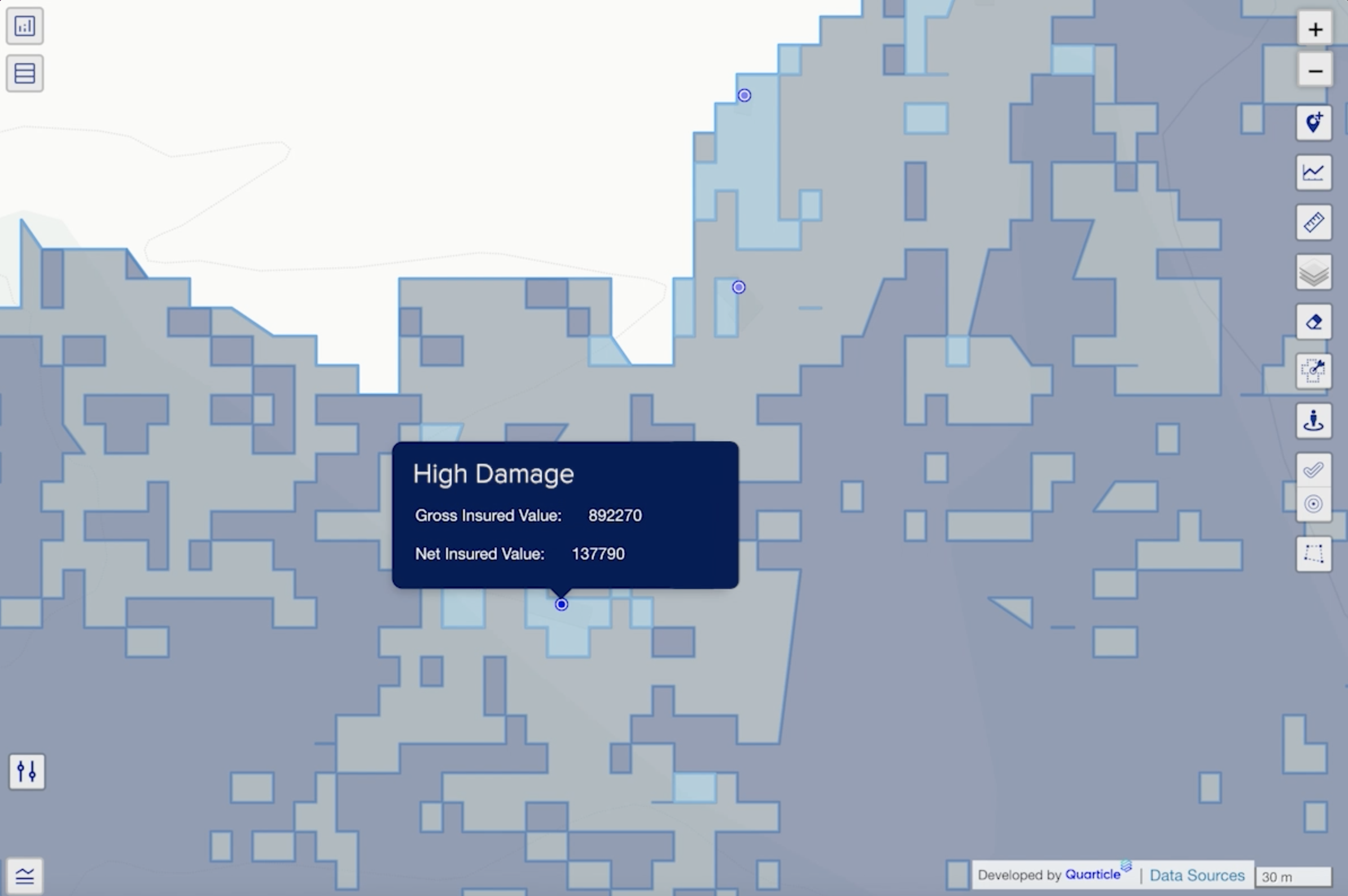
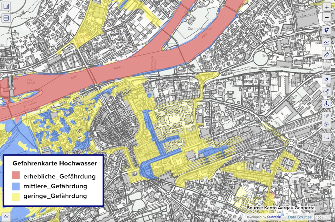
The Quarticle Risk Prevention and Resilience Intelligence solution empowers insurers with proactive risk management by integrating real-time geospatial analysis and field data capture directly into underwriting, claims, and engineering workflows, enabling risk managers to identify and mitigate exposures before they result in costly claims.

Graph by Quarticle geospatial intelligence app displays a detailed map of Aargau Canton, featuring a grey buildings layer overlaid with a flood hazard layer. The flood risk is color-coded: red areas indicate significant risk, blue areas highlight moderate risk, and yellow areas represent low risk. A legend titled "Gefahrenkarte Hochwasser" explains the risk categories, and the interactive map tools are visible on the right.
What it delivers
Early Risk Identification
Leverage official hazard models, such as regional flood mapping from the Argau canton in Switzerland, combined with insured portfolio footprints to identify vulnerable exposures. Emphasize risk mitigation and management consulting to guide proactive identification, prioritization, and effective mitigation strategies before risk escalation.
Automated Mitigation Guidance
Generate detailed digital dossiers with actionable, prescriptive recommendations that prioritize mitigation strategies. Support compliance with regulatory frameworks and building permit requirements to ensure you can proactively manage risks and meet all necessary legal obligations effectively.
Field-Enabled Assessments
Empower risk specialists with the Mobile Editor app for efficient onsite data capture, with seamless real-time synchronization to central systems, enabling rapid, informed decision-making.
Operational Efficiency
Enhance the connectedness of the entire risk management chain by providing seamless access to relevant data, from building details and prior claims history to damage assessments. This integration enables underwriters, claims handlers, and damage prevention experts to collaborate effectively using unified spatial workflows.
Vendor Independence
Rely on fully OGC-compliant services designed to maintain autonomy and avoid costly vendor lock-in, ensuring scalability and organizational control.

Key Outcomes for Insurance Teams

Proactive loss prevention through early spatial risk insights
Coordinated mitigation planning to prevent large-scale losses
Connected workflows across prevention, engineering, and claims teams
Seamless compliance with automated digital prevention dossiers
Scalable rollout from core tools to full AI-driven analytics
Map visualization shows building footprints, flood hazard zones, and an urban zoning plan. Next to the map, there is a photo of a road sign partially submerged by floodwaters and a hazard warning icon. The combined image illustrates how flood risk mapping is integrated with urban planning and civil engineering for hazard management.

Built for the Demands of Insurance Risk

Powered by our scalable Qarta™ cloud-native GeoIntelligence engine and the Graph interactive location intelligence app, the platform integrates easily with your existing systems to deliver timely, accurate insights. From early hazard detection to field assessments, it equips underwriting, claims, and engineering teams with the data they need to enhance prevention and reduce losses.

Who Benefits

Underwriters
Gain a richer risk context for more accurate pricing and portfolio management.
Risk Engineers & Surveyors
Conduct efficient onsite assessments and prioritize remediation efforts.
Claims Managers
Enable early intervention with damage-limiting, actionable recommendations.
Exposure Managers & Cat Teams
Support real-time accumulation monitoring and proactive prevention planning.
Ready to move from reactive to proactive risk management?