Portfolio Data Enrichment Engine

Transform raw insurance data into actionable risk intelligence in seconds
Instantly transform messy insurance data into clean, enriched risk intelligence, ready for modeling, reporting, and decision-making at scale.
Digital map interface with location pin and geospatial analysis tools on the right side, presented in Graph, Quarticle’s location intelligence application.
Trusted by
“Blazing fast, cost-efficient, and easy to integrate, RAPID empowers our renewal processes and risk modeling. Fully automated geoprocessing and geo-enrichment of smaller books or larger portfolios are no longer an issue. We have reduced the amount of human intervention by more than 300%. From Core Insurance Systems to Scenario Modelling, all are connected and enabled within a short implementation phase.”
Former Head of GIS, Global P&C Insurer with 150,000+ Employees

Client Success Stories

The largest first insurer in the world reduced costs by 65% and drastically improved performance by replacing their existing GIS solution provider with the Qarta™ geo engine
How the largest first insurer in the world replaced previous solutions with Quarticle’s cloud-native, user-friendly risk assessment suite
Enhancing GIS Performance and Flood Data Management in Europe for the Switzerland-based Global Reinsurance Leader
Image showing CSV data enrichment in Graph by Quarticle. The sidebar contains portfolio, data layers, live events, and event footprints sections. The main area displays a map with scattered data points, and below it, a data enrichment results table.

Clean, Reliable Insurance Data at Scale

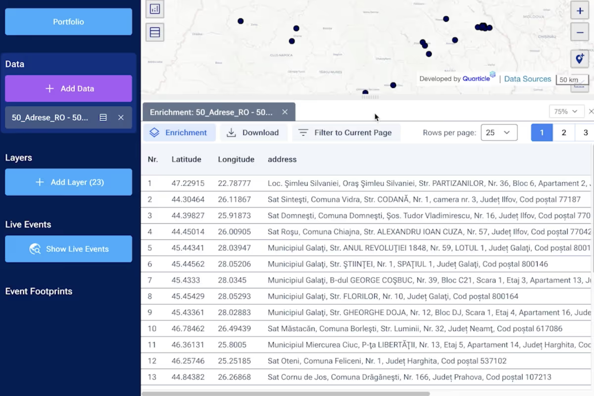
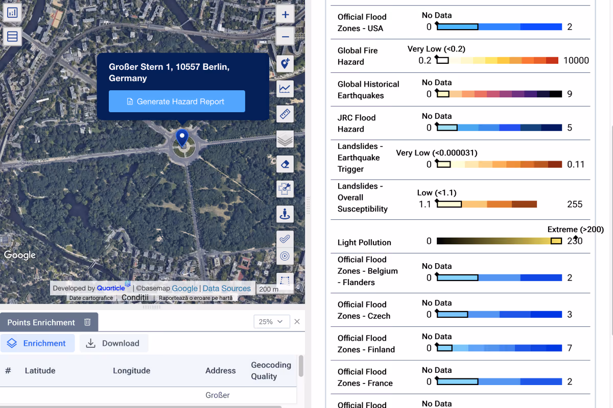
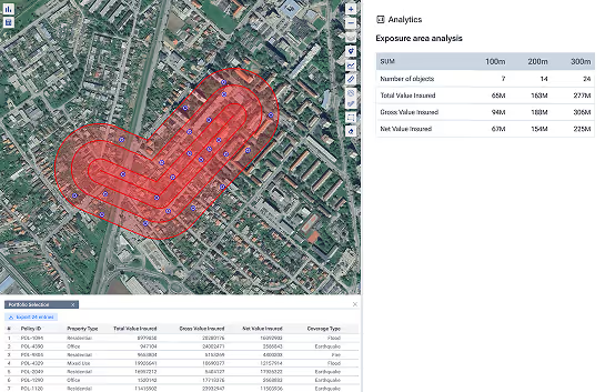
The Portfolio Data Enrichment Engine transforms raw, location-based insurance data into structured, enriched, and trusted datasets ready to support accurate risk modeling, pricing decisions, and compliance workflows. It eliminates delays and ensures data quality from the start.

What it delivers
Automated data cleansing
Detects and removes duplicates, repairs errors, and harmonizes formatting to eliminate the need for repetitive manual QA.
Location intelligence at scale
Enrich portfolios with risk scores, natural hazard layers (flood, fire, etc.), demographic overlays, and custom business data across millions of records in seconds.
Real-time integration
Built to work with your existing systems, claims, policy, exposure, or reinsurance via powerful APIs. Whether you want a standalone enrichment process or to embed it in a broader platform, it adapts to your workflow.
Live-event enrichment
Layer live CAT raster data (e.g., flood zones, wildfire perimeters, storm tracks) over your current portfolio to instantly identify affected exposures and issue early loss estimates.

Key Outcomes for Insurance Teams

solution
Faster risk modeling with enriched data that’s analysis-ready from day one.
solution
Improved compliance posture with transparent data handling and auditability.
solution
Higher confidence in decisions based on validated, real-time location intelligence.
solution
Accelerated onboarding of new books and renewals, including bulk portfolios.
solution
Reduced operational load through full automation of the enrichment pipeline.

Built for the Demands of Modern Insurance

High-Speed Processing 
Over 2M records per second, even on a single instance.
Comprehensive Enrichment 
Multi-risk insights delivered in a single pass.
Scalable for Any Portfolio 
One engine for both small books & multi-million-point datasets,.

Who Benefits

Underwriting & Risk Modeling Teams
Reduce data preparation time and increase model input quality.
Claims and Catastrophe Chief Managers
Gain rapid visibility into affected policies and act accordingly.
Portfolio Managers
Understand accumulations and risk hotspots instantly.
Reinsurance and Exposure Analysts
Ensure enriched, normalized data is ready for submission or transfer.
Want to turn raw insurance data into real insight at scale?
Deliver sharper risk decisions with clean, enriched datasets.