AI-Ready GeoIntelligence for Enhanced P&C Insurance Business Value

Leading the Transformation in Property & Casualty Insurance Operations with Comprehensive Geospatial Intelligence
A business professional using a laptop with digital security and data protection icons overlaid, symbolizing cyber resilience, risk management, or compliance.
Quarticle empowers P&C insurers and reinsurers with a unified geographic logic layer, integrating exposure, claims, hazard, geopolitical data, and climate data through APIs and model-ready dashboards.

Critical Challenges Facing P&C Insurers Today

Extreme Weather and Natural Catastrophes

More frequent and severe storms, floods, and wildfires cause unpredictable losses and rising claims.

Climate Change and Earth System Shifts

Long-term climate changes increase hazard frequency, severity, and geographic reach.

Geopolitical Instability and Risk

Conflicts and unrest cause fast-growing accumulation risks, and demand real-time monitoring.

Financial and Business Disruption

Disasters, conflicts, and tech failures disrupt operations, triggering major claims and coverage demands.

Compliance Pressure

Stricter regulations require precise risk visibility to avoid fines, reputational damage, or license loss.

Outdated Technology and Operational Inefficiencies

Legacy systems and fragmented data slow risk assessment and drive up costs.

Financial Strain and Risk Mispricing

Misallocated capital, underpriced risks, and slow quoting reduce profits and competitiveness.

Biodiversity Loss and Ecosystem Collapse

Ecosystem decline disrupts supply chains and raises risks in agriculture and specialty insurance.

How We Solve These Challenges

Diagram of Quarticle GeoIntelligence Solutions at the center, connected to key insurance roles including Chief Risk Officer, Chief Underwriting Officer, Chief Actuary and Pricing Officer, and others.

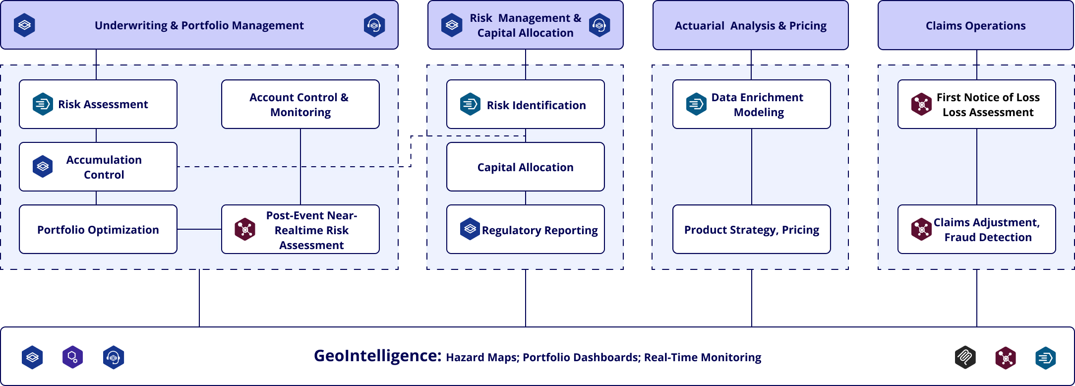
A Single Source of Geospatial Truth: Quarticle's Insurance-Focused GeoIntelligence Platform

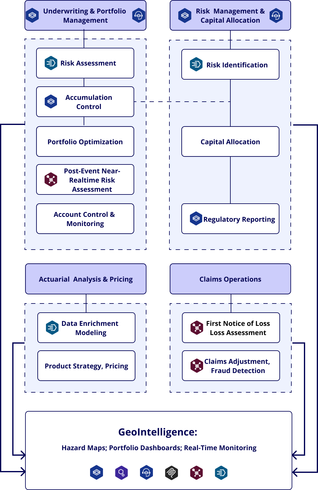
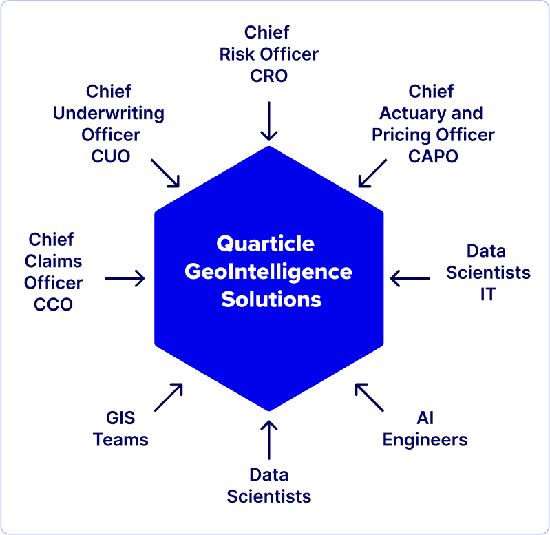
Quarticle delivers a single source of geospatial truth across the insurance value chain, enabling real-time analytics, regulatory-grade risk insights, and scalable underwriting support for the largest insurers and reinsurers.

Purpose-Built Solutions for Insurance Transformation

Compliance

Demonstrating to regulators that every policy meets risk standards with transparent, verifiable geospatial evidence.

Risk Mitigation

Preventing losses by identifying hazards and accumulations early and acting before risks escalate into claims.

Pricing Accuracy & Profitability

Protecting margins with precise, location-based risk data to eliminate mispricing.

Portfolio Management

Balancing your portfolio by identifying exposure concentrations and diversifying by geography and peril.

Accumulation Control

Monitoring exposure clusters in real time to protect annual profits from a single loss event.

Capital Allocation

Deploy capital and reinsurance accurately and efficiently to maximize returns and avoid overexposure.

Operational Efficiency

Streamlining underwriting with integrated geospatial workflows that reduce costs and complexity.

AI Readiness

Building reliable, compliant AI models on a foundation of clean, structured location data.

Real-World Impact for Global Insurance Leaders

Scale & Adoption

More than 15,000 Property & Casualty (P&C) underwriters use our tools daily worldwide
API integrations enable consumer interactions across customer engagement platforms
Seamless broker and aggregator workflows through integrated systems
Global deployment with multi-language support

Regulatory Compliance Achievements

Full VAIT and DORA compliance with privileged access management
Successful regulatory audits with enhanced risk reporting capabilities
Streamlined compliance processes, reducing administrative burden
Improved risk transparency for supervisory authorities

Cost Benefits

65% cost reduction achieved by major clients
More than 150 physical servers consolidated to 1 server cluster
Unlimited user seats without additional costs
The Quarticle GeoIntelligence Advantage
Unified Risk Intelligence Platform
Integrate all critical geospatial datasets (hazard zones, exposure records, claims history, accumulation layers) into a single, AI-ready platform built for enterprise insurance operations — no silos, no fragmentation.
Address-Level Risk Precision
Deliver accurate, multi-peril risk scoring at the individual property level (far beyond postal code aggregates), enabling smarter underwriting, precise pricing, and confident risk selection in every market and regulatory environment.
Compliance by Design
Meet and exceed regulatory demands with validated datasets, audit trails, and pre-configured compliance workflows aligned with VAIT, DORA, BaFin, and IFRS17. Compliance isn’t an afterthought; it’s engineered into every process.
Strategic Risk Intelligence for Executives
Equip CUOs, CROs, CAPOs, and Capital Allocation Leaders with live dashboards delivering actionable insights on risk accumulation, cross-border exposure, capital efficiency, and underwriting profitability, from enterprise-wide trends down to single-location details.

 Comprehensive GeoIntelligence for Modern Insurance

Underwriting & Portfolio Management:

Use integrated hazard maps and proximity data to assess risk, price policies more accurately, monitor exposure in real time, and optimize portfolios across borders.

Post-Event Risk Assessment:

Instantly integrate event footprints (e.g., NOAA, ESA), assess impacted portfolios, and support rapid claims triage and re-underwriting with real-time updates.

Risk Management & Capital Allocation:

Identify and aggregate exposure across portfolios, model catastrophe scenarios, optimize capital allocation, and generate VAIT/DORA-compliant reports with spatial precision.

API & Workflow Integration

API integrations with other systems enable consumers on our customers' engagement platforms to interact with their aggregators and brokers, creating seamless workflows across the entire insurance ecosystem.

Accumulation Control

Enrich data with hazard zones and event history, build predictive pricing models, design region-specific products, and analyze portfolio impact at scale in seconds.

Claims Operations:

Quickly geolocate loss events, assess severity with real-time data, prioritize claims, dispatch adjusters efficiently, and detect fraud through location-based pattern analysis.

Modular Solutions That Deliver Immediate Results

Quarticle Products

Overview of Geo-Enhanced Business Functions

Overview of geo-enhanced business functions through Quarticle products, showing how geospatial intelligence supports insurance processes across four areas: Underwriting & Portfolio Management, Risk Management & Capital Allocation, Actuarial Analysis & Pricing, and Claims Operations.

Business Outcomes

Harmonized application landscape across enterprise systems
Improved underwriting decisions and increased margins
Centralized geospatial workflow management
Enhanced customer and broker service delivery
Eliminated system outages and service unavailability
Bridged claims, exposure, and climate data through unified workflows

Client Portfolio

Largest Insurer in the world and its regional and affiliates
Switzerland-based global Reinsurance Leader
Government Agencies
One of the largest Eastern European Logistics Firm
Panoramic view of Munich city center, overlaid with Fortune 100 and Fortune 500 logos, highlighting global business presence.
Discover how leading insurers are navigating today’s critical climate challenges with cutting-edge geospatial intelligence. Join Quarticle’s Climate Events series across key European cities to gain exclusive insights, network with industry experts, and unlock innovative strategies for risk mitigation, compliance, and profitability.
Subscribe to our newsletter to be the first to know when registration opens

What our customers are saying

Blazing fast, cost-efficient, and easy to integrate, RAPID empowers our renewal processes and risk modelling. Fully automated geoprocessing and geo-enrichment of both small books and large portfolios is no longer a challenge. We’ve reduced human intervention by more than 300% — from core insurance systems to scenario modelling, everything is connected and enabled within a short implementation phase.

Former Head of GIS, Global P&C Insurer with 150,000+ Employees

Quarticle’s geospatial intelligence platform allowed us to harmonize our application landscape. We can now manage all geospatial workflows centrally, driving efficiency and effectiveness across our underwriting operations. Providing our customers and brokers with significantly faster, higher-quality services not only reduces operating costs, improves underwriting decisions, and increases margins — it also enables us to deliver a best-in-class experience to our users.

Former Head of GIS, Global P&C Insurer with 150,000+ Employees

Quarticle's solution drastically improved our GIS performance and data accuracy, allowing us to manage natural hazard risks more effectively. Their expertise in handling complex geospatial data on Microsoft Azure was instrumental in achieving our objectives.

Former Head Geospatial Risk Insights, Global ReInsurer

Schedule a tailored demo or strategy session today.