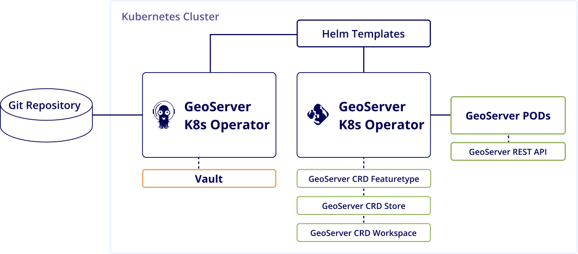
Cloud-Native Geo Intelligence Engine

Streamline your geospatial analysis and deliver real business value with Qarta™ by Quarticle

To satisfy the current high market demands we’ve built Qarta™, a powerful, cloud-native, highly scalable geo intelligence engine designed to deliver geo content quickly, flexibly, and securely.

Download Product Brief

Qarta™  at a glance

Qarta by Quarticle API at a glance showing how geospatial data is managed and delivered to end users like developers, admins, product owners, subject matter experts, data scientists, GIS experts, and managers

Built for Insurance Workflows

Insurers use Qarta™ to:

Deploy risk intelligence inside your underwriting platform

Integrate Qarta™ via API into existing underwriting and claims systems

Enrich and cleanse policy and exposure data

Automatically standardize formats, remove duplicates, and enhance portfolios with spatial attributes.

Perform high-speed geospatial queries

Execute large queries and get results across millions of records in seconds.

Scale confidently during renewals or catastrophe seasons

Qarta’s cloud-native architecture supports horizontal scaling and manages peak demand without compromising performance.

Maintain data sovereignty and compliance in any deployment

Operate in regulated, sovereign, or hybrid cloud environments with flexible security, access control, and deployment models.

Client Success Stories

The largest first insurer in the world reduced costs by 65% and drastically improved performance by replacing their existing GIS solution provider with the Qarta™ geo engine
How the largest first insurer in the world replaced previous solutions with Quarticle’s cloud-native, user-friendly risk assessment suite
Enhancing GIS Performance and Flood Data Management in Europe for the Switzerland-based Global Reinsurance Leader
What it delivers
Streamlined API Integration
Qarta™ is a powerful tool that can function as your API. You can integrate it into existing applications and user interface, or use it with our front-end solution, Graph. Additionally, you can access technical documentation for Qarta™ through Swagger (which allows you to describe the structure of your API in a machine-readable format).
Get access to data in seconds
Established GIS server vendors still use a VM-oriented architecture, which makes the system less flexible, and causes increased costs for both hardware and software. Qarta™, however, is faster process-wise, because it splits tasks into smaller bundles that are easier to execute. It automatically distributes the workload through a load balancer to all available nodes.
Experience the power of cloud-based software
​​Qarta™ is a Software-as-a-Service (SaaS) offering, which Quarticle runs in your preferred cloud provider environment and in alignment with your cloud services spending and budgeting. We work with any cloud provider (Google, AWS, Azure) since we use Kubernetes.
Remove the hassle of scalability
Qarta™ brings cloud scalability for your quarter endings and monthly reporting. It scales horizontally when higher performance demand and data load increase, and scales down when you have lower needs for data analytics.
Easily integrate Qarta™ into your enterprise
Qarta™ seamlessly integrates with Azure Active Directory while featuring its dedicated security infrastructure designed for diverse roles and user access rights. This ensures user-friendliness for large organizations with multiple access criteria.

Deployment Options

Managed cloud environments
Private clouds
On premise

Who Benefits

Underwriters & Pricing Analysts
CAT Modelers & Risk Managers
Reinsurance & Exposure Management Teams
Compliance & Regulatory Reporting Teams
Geospatial Analysts
IT/Data Engineering Teams
Ready to unlock real portfolio intelligence?
Leverage Qarta™ for real-time accumulation control, enriched data, and portfolio-ready intelligence.