
Predictable Costs, Scalable Intelligence: Why Transparent Pricing Matters in GeoIntelligence

When organizations invest in geospatial technology, they’re not just buying software; they’re committing to an ecosystem that will shape their operational capabilities for years. Yet, too often, pricing models in this space are complex, unpredictable, and tied to restrictive licensing schemes that grow costlier as you scale.
At Quarticle, we decided to take a different path. Our pricing and licensing model is built around three simple principles: clarity, scalability, and freedom.
Clarity that builds trust
Every Quarticle product (whether it’s Qarta™, Graph, RAPID, or EventHUB) is offered under a flat annual subscription that’s fixed for the duration of your contract. That means no hidden costs, no surprise renewals, and no creeping fees as your usage grows. Our clients know exactly what they’ll pay, year after year, for software, maintenance, and enterprise-grade support.
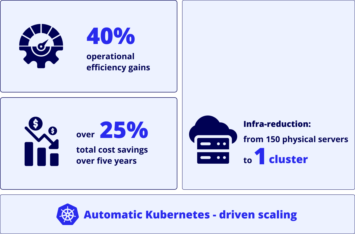
This predictability translates into a total cost reduction of roughly 25–30% over five years compared to traditional GIS licensing models, where add-ons, user limits, infrastructure constraints, and charges for computational operations such as geocoding and data processing can quietly inflate budgets.
Scalability without boundaries
Legacy GIS platforms often tie performance and pricing to user counts and user types, such as contributors, viewers, or mobile workers, forcing organizations to balance cost against capacity and access levels.
Quarticle’s architecture is cloud-native and powered by Kubernetes, enabling automatic and efficient scaling whether serving 10 analysts or 10 million users. While supporting more users requires additional hardware, each core can handle many user requests concurrently, and increasing threads per core allows for more simultaneous operations, ensuring consistent reliability and performance as workloads grow.
This modern architecture eliminates over-provisioning and unnecessary license costs, delivering up to 40% operational efficiency gains by aligning infrastructure use with real demand. It also drastically reduces the cloud footprint by running on a single Kubernetes cluster and lowers costs further by using PostGIS, which reduces or eliminates the need for expensive proprietary database licenses.
Freedom through open standards
Vendor lock-in is one of the most expensive problems in enterprise software, and it’s often invisible until the time of migration. With Quarticle, you avoid that entirely.
All our products are based on OGC-compliant open standards and integrate natively with technologies like PostGIS, GeoServer, and QGIS. That means your data remains portable, interoperable, and under your control.
You can switch infrastructure, cloud providers, or even discontinue our services at any time. We believe our customers should stay because they want to, not because they’re locked in.
Enterprise reliability you can count on
The Quarticle Enterprise Edition runs on a Kubernetes-driven cloud platform offering 99.9% availability, full SLA commitments, and dedicated support plans (standard 8×5 or premium 24×7). For insurers operating in regulated and mission-critical environments, this means robust continuity, compliance, and confidence.
Each customer gets a tailored SLA aligned with their operational goals. Because our platform is cloud-agnostic, you can deploy on Azure, AWS, or your preferred local provider without friction. Our clients value this combination of reliability and flexibility, particularly when business continuity and compliance are non-negotiable.
When you look at the full picture (software, support, consulting, and infrastructure) Quarticle consistently delivers over 25% total cost savings compared to traditional GIS environments.
Quarticle’s pricing model wasn’t designed to compete on short-term discounts. It was designed to empower long-term success. With flat, predictable costs, cloud-native scalability, and open interoperability, we help organizations build sustainable, future-proof GeoIntelligence capabilities without financial surprises or technical constraints.
If you're ready to review your Return on Investment (ROI) and perform a Total Cost of Ownership Calculation (TCO) over 5 years free of charge, drop us a message or book a meeting with our experts.
