

How to Plan Your Geo Project for Maximum Business Success

Designing and delivering a successful geospatial or location intelligence project goes far beyond technical implementation. It requires strategic clarity, business alignment, and the ability to bridge the gap between opportunity and execution.
Many organizations face challenges such as incomplete requirements, slow adoption, or solutions that fail to scale. A well-structured plan can transform these challenges into drivers of value, actionable insights, and operational excellence.
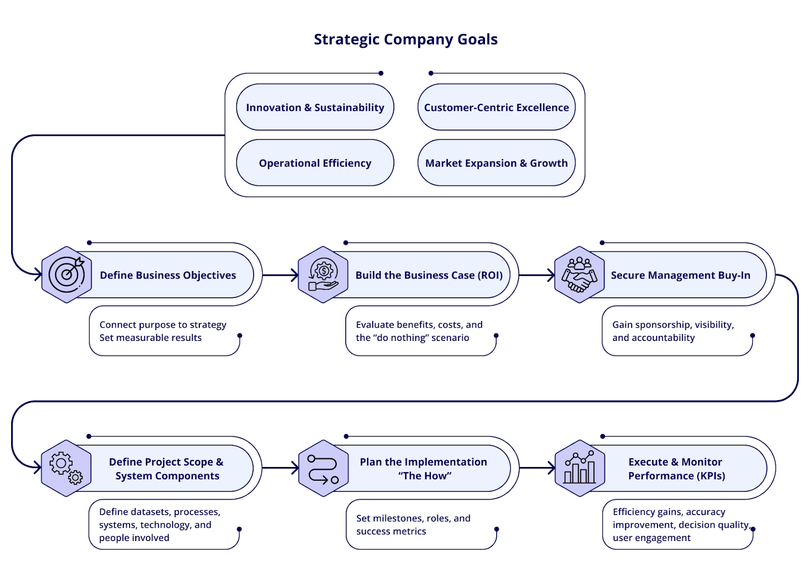
Here’s a practical six-step framework rooted in real industry experience that any organization can adopt for consistently successful results.
1. Start with a clear business objective
Every impactful project begins with a simple but powerful question: “What business problem are we solving?”
When the objective is clear, everything else becomes easier: data selection, architecture, integrations, success metrics, and stakeholder alignment. Whether you're optimizing logistics routes, improving asset visibility, accelerating due diligence workflows, or enhancing spatial analytics, clarity ensures your project creates measurable value rather than producing yet another dashboard no one uses.
2. Define what the system must do
After establishing the business objective, the next step is to translate it into concrete system requirements. This is where vague objectives become actionable capabilities.
Not every feature deserves equal weight. Some capabilities are essential to achieving the strategic goal, while others are simply nice-to-have. Making this distinction early brings focus to your team and keeps the project from expanding endlessly. It also helps leadership understand what the system will actually deliver.
3. Validate feasibility through quick industry research
Before committing resources, take time to explore how similar organizations have addressed comparable challenges. This doesn’t need to be an exhaustive benchmark, just enough to understand the viability of your approach, the data sources commonly used, and the performance levels you should expect.
Seeing real-world examples of scalable, cloud-native geospatial engines or successful automation workflows helps remove uncertainty and sets realistic expectations for your own project.
4. Evaluate the “Do Nothing” scenario
One of the most revealing planning exercises is considering what happens if the organization decides not to act. Often, the cost of maintaining the status quo far outweighs the investment in modernizing.
This could mean continued reliance on manual processes, slow decision cycles, incomplete visibility, rising operational costs, or being unable to meet new regulatory or reporting requirements. Articulating these consequences gives your business case a sharper edge and creates urgency where it may currently be lacking.
5. Plan the “How” with a clear technical blueprint
Only once the “why” and “what” are crystal clear is it time to design the “how.” This phase is about shaping the architectural and operational plan: identifying the datasets you’ll rely on, the models you’ll use, how data will move through the system, who will operate it, and how the solution will scale as its value grows. Modern geo projects increasingly rely on cloud-native engines, automated enrichment pipelines, and API-first integrations to ensure performance and long-term flexibility.
A solid blueprint prevents technical drift and keeps everyone, from analysts to engineers to executives, aligned on how value will be delivered.
6. Secure management buy-in before prototyping
Even the best-designed geo project can struggle without strong executive sponsorship. Leadership needs a clear understanding of the expected impact, projected ROI, and timeline.
This isn’t just about getting approval; it’s about ensuring visibility, alignment, and momentum. When decision-makers understand the strategic importance of your project, adoption accelerates and resources become easier to secure.
Turning Planning Into Results
A successful geo initiative doesn’t start with software or datasets; it starts with clarity, alignment, and an understanding of the business impact. By following this sequence: objective, requirements, feasibility, ROI framing, technical planning, and stakeholder engagement, you dramatically increase your chance of building a system that scales and delivers real value across the organization.
Are you considering a new geospatial project or seeking to scale your organization’s use of location intelligence? At Quarticle, we empower teams across industries to design, build, and deploy high-performance spatial solutions, cloud-native, API-driven, and ready for tomorrow’s challenges. Connect with our team to learn how Quarticle can accelerate your next project, or request a live walkthrough tailored to your use case.
