

From Static GIS to Real-Time Routing Platforms

For many logistics operators, field service organizations, mobility platforms, and transportation networks, GIS started as a map. It showed where assets were located, where partners operated, and where customers were concentrated. For planning, reporting, and territory design, that was more than enough.
However, operational environments have evolved significantly. Response times became tighter. SLAs left less margin for error. Customers began to expect real-time updates. Dispatch teams no longer had the luxury of looking at a map, discussing options, and calling around. Decisions now have to be made quickly and with confidence. In this setting, a static map that reflects yesterday’s data is no longer sufficient.
Moving from static GIS to a real-time routing platform is not about nicer visualization. It is about whether location data actively supports operational decisions or simply illustrates them.
When a Map Is Not Enough
Traditional GIS systems are very good at answering spatial questions. Where is something located? What falls inside a defined area? What is the distance between two points?
But operational teams ask different questions.
- Who can actually reach this location in under ten minutes?
- Which partner is not only close, but also available, qualified, and under the correct contract?
- Which option meets cost targets and SLA commitments at the same time?
These are not theoretical questions. They determine who gets dispatched, how fast a customer is helped, and how much a case will cost. In many organizations, GIS still sits slightly outside core operational systems. Data is exported from ERP, CRM, or dispatch tools into a geo-database on a schedule, so the resulting map reflects yesterday’s data.
For reporting, this delay is usually acceptable. But in real-time dispatch or assistance scenarios, it creates friction: partners who have changed status may still appear available, temporary closures are not reflected immediately, and new service providers take time to appear. Operators must manually combine geographic information with contract details and performance data stored across different systems.
As a result, the map serves as a visual reference, but not as a reliable decision-making system.
What Actually Changes with a Routing Platform
A real-time routing platform addresses this gap by integrating routing directly into operational workflows.
- The first fundamental shift is data freshness. Instead of relying on nightly updates, partner and location data are synchronized continuously or near real-time. When an address changes, a capability is updated, or a contract status shifts, that information becomes operationally usable immediately. Travel-time calculations are based on current data, not outdated exports.
- Second, routing platforms are built around a spatial data model that understands more than coordinates. A location is linked to attributes: service categories, equipment types, priority levels, opening hours, temporary closures, and contract status. Routing decisions can therefore reflect business rules, not just distance.
- The third shift is that routing itself becomes a core service, not a visual add-on.
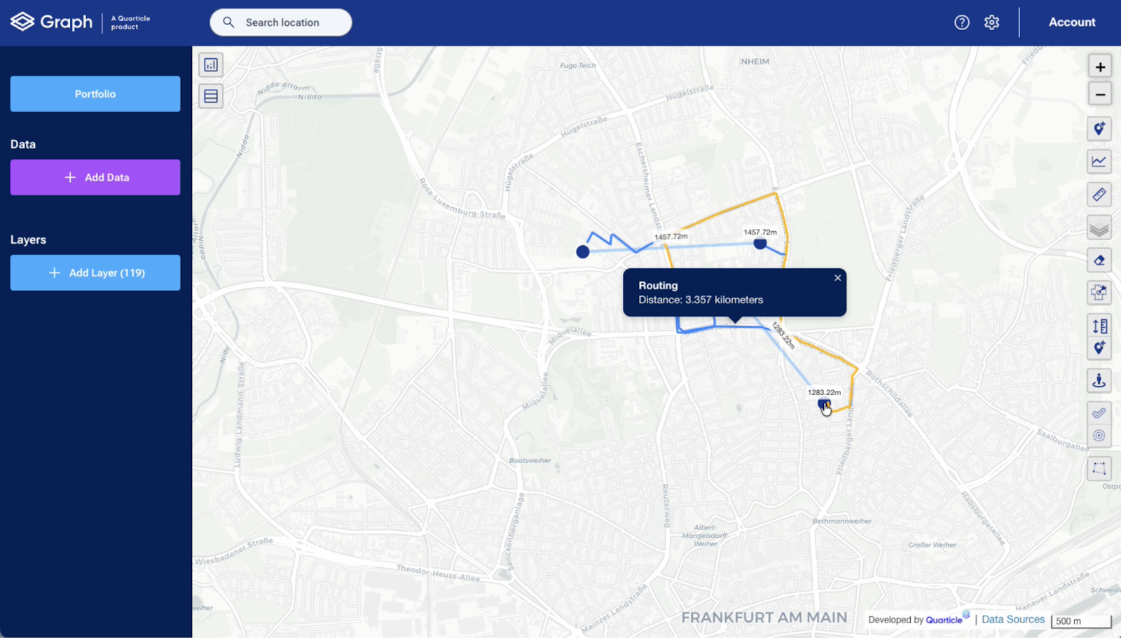
Modern routing modules do far more than draw a line between two points. Engines such as Valhalla provide a strong open foundation and can be extended, where required, with providers like HERE or Google Maps. They calculate routes, travel times, isochrones, and distance matrices across large sets of locations.
At Quarticle, the Routing module is built exactly around these core functions. Based on Valhalla as a standard engine and extendable with commercial providers when needed, it delivers routing, isochrones, and distance matrices as reusable services. Road and air distances, as well as travel time calculations, are part of the baseline functionality.
A Practical Operational Scenario
Consider a typical dispatch case in a logistics or field service context.
An event is reported, and the exact coordinates are captured automatically. The routing engine calculates a travel-time area around the event location: for example, all providers reachable within ten minutes by road. Within that area, the system filters partners according to defined criteria: service category, equipment type, contractual eligibility, and availability.
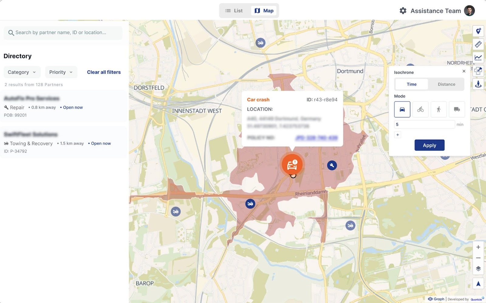
Instead of looking at dozens of pins on a map, the operator sees a ranked shortlist. The selection is made. The route is generated. Communication is triggered automatically.
In this process, routing is not a separate step. It is integrated from the moment the event is created until the assignment is confirmed.
That integration is what transforms GIS from a visualization tool into an operational infrastructure.
The Strategic Implication
Once routing decisions influence cost, SLA performance, and customer satisfaction, they can no longer rely on static data or disconnected systems. The key question for logistics and transportation organizations is simple:
Is routing something you look at, or something your operations run on?
Static GIS remains valuable for planning and analysis. But when dispatch, coverage, and partner selection depend on travel time and availability, routing has to be integrated, current, and governed properly.
In the next article in this series, we will look at the architectural side of this shift and examine what actually matters when designing routing platforms for reliability, scalability, and long-term operational stability.
