

Leveraging GIS for Faster and Smarter Natural Disaster Response

For insurers, governments, and logistics providers, natural disasters aren’t just tragic events; they are high-stakes stress tests of resilience. Each flood, wildfire, or earthquake brings portfolio risk, regulatory pressure, and operational disruption into sharp focus. To respond effectively, organizations need more than hazard data; they need decision-ready geospatial intelligence.
This is where Geographic Information Systems (GIS) play a crucial role. By analyzing and visualizing spatial data, GIS helps experts understand risk, enhance response efforts, and plan recovery strategies more effectively. From early warning systems to post-disaster reconstruction, GIS is transforming how we manage natural disasters.
Predicting and Preparing for Disasters
The first step in alleviating the impact of natural disasters is understanding where they are most likely to occur and preparing accordingly. GIS enables data scientists and policymakers to analyze historical data, identify patterns, and predict areas at high risk.
For example, in flood-prone areas, GIS integrates hydrological models, elevation data, and climate patterns to determine which regions are most vulnerable to rising waters. Governments can then use this information to:
- Develop zoning regulations that prevent construction in high-risk areas.
- Strengthen flood defenses, such as drainage systems.
- Design evacuation plans based on population density and road networks.
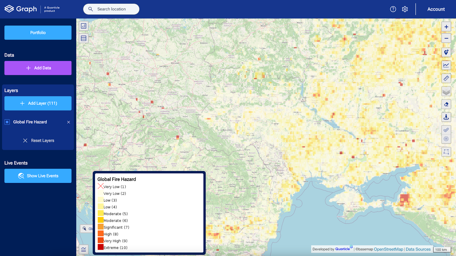
Similarly, in wildfire-prone regions, GIS combines vegetation mapping, wind patterns, and temperature data to identify areas at risk. This allows authorities to strategically place firebreaks and allocate resources to prevent fires from spreading. By leveraging real-time hazard mapping, decision-makers can proactively mitigate risks rather than reacting after a disaster has struck.
Using RAPID by Quarticle, insurers, for example, can overlay climate projections with client portfolios to identify where exposure clusters exceed acceptable thresholds. This moves disaster preparation from a government-only function to a portfolio-level resilience strategy for businesses and insurers.
Enhancing Emergency Response
When disaster strikes, every second counts. GIS provides emergency responders with real-time situational awareness, allowing them to act quickly and efficiently. During an earthquake, for instance, GIS can overlay seismic activity data with population density maps to identify the areas most severely affected. This helps first responders prioritize search-and-rescue operations and deploy resources where they are needed most.
For hurricanes and typhoons, GIS is used to track the storm’s path and anticipate which areas will be affected. Emergency response teams can then:
- Set up evacuation routes in advance.
- Position relief supplies in safe zones.
- Establish temporary shelters for displaced residents.
GIS also plays a key role in coordinating multiple agencies during disaster response. By integrating live drone footage, satellite imagery, and sensor data, responders can get a comprehensive view of the disaster zone and make informed decisions in real time.
When disaster strikes, Quarticle’s EventHUB doesn’t just capture event data; it streams live hazard footprints and portfolio overlays into decision workflows. During the Central Italy earthquake, this meant insurers could estimate billions in exposure within minutes, rather than weeks.

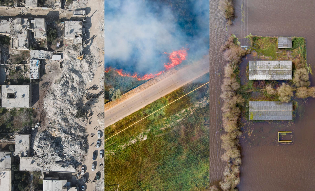
Assessing Damage and Planning Recovery
After a natural disaster, GIS helps authorities assess the extent of damage and prioritize recovery efforts. By comparing before-and-after satellite images, analysts can determine:
- The number of buildings and roads destroyed.
- The areas that are still inaccessible to emergency teams.
- The regions where basic services (electricity, water, communication) are needed for restoration.
For example, after a major flood, GIS tools can create flood depth maps to estimate property damage and insurance claims. This allows governments and aid organizations to allocate financial assistance effectively and help communities rebuild. GIS also supports long-term resilience planning. Post-disaster analysis helps policymakers identify:
- Infrastructure weaknesses that need reinforcement.
- Regions that should have stricter building codes.
- Communities that need better evacuation planning for future disasters.
Beyond immediate relief, geointelligence feeds directly into actuarial models and capital planning. By quantifying losses at the building level, insurers can refine risk pricing, regulators can ensure solvency, and governments can prioritize infrastructure upgrades. This is where Quarticle’s integration of socio-demographic data with hazard intelligence gives decision-makers an edge.
International Disaster Risk Reduction Day: A Reminder to Act
Coming up on October 13th, International Disaster Risk Reduction Day serves as a vital reminder of the global commitment to reducing disaster risks and enhancing resilience. This day highlights the importance of using advanced tools like GIS to better understand hazards, coordinate responses, and build safer communities worldwide. Leveraging geospatial intelligence can help ensure that disaster preparedness and recovery efforts are smarter, faster, and more effective.
The Future of GIS in Disaster Management
Advancements in GIS technology are continuously improving disaster response and mitigation. The integration of AI, machine learning, and cloud computing allows for faster data processing, more precise modeling, and real-time updates.
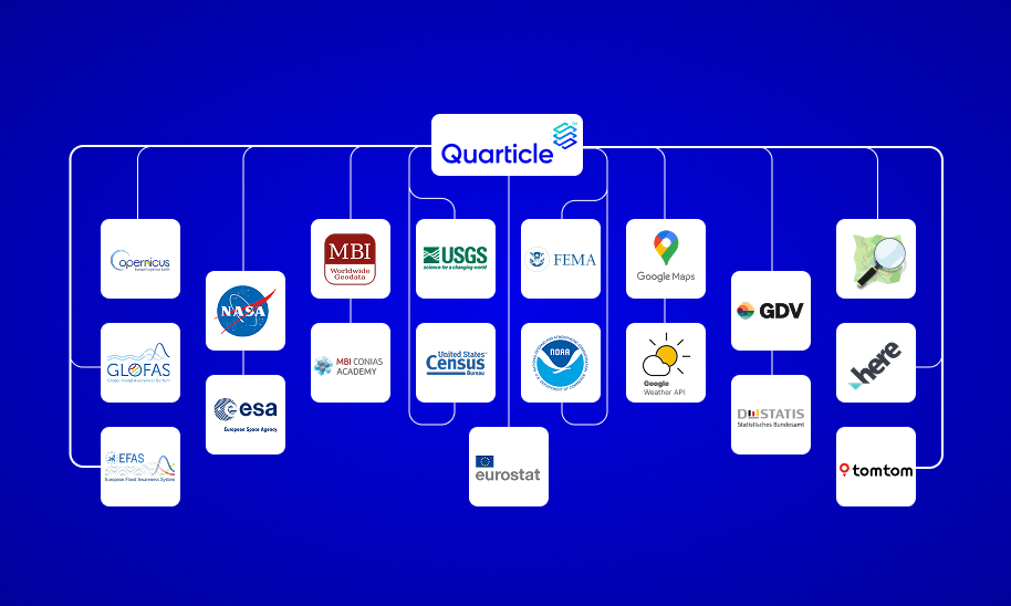
At Quarticle, we understand that geospatial intelligence is more than just mapping; it’s about transforming complex data into actionable insights. Disaster management isn’t a stand-alone exercise; it’s part of an AI-ready geointelligence ecosystem. With RAPID enriching raw data, Graph visualizing risk layers, Qarta™ powering portfolio decisions, and EventHUB capturing live events, we deliver resilience at every stage of the disaster cycle.
