Clients & Partners

Critical Challenges Facing P&C Insurers Today:

Increasing CAT Volatility and Climate Exposure
Escalating Cloud Costs
Fragmented Risk and Geospatial Data
Regulatory and Audit Pressure
Slow Geo-Enrichment and Underwriting Workflows
Lack of Real-Time Portfolio Transparency
Legacy GIS Engines That Don’t Scale
Geopolitical Instability and Accumulation Risks

Why Quarticle for Insurance

225,000+
Hours Focused on Insurance GeoIntelligence
Over a decade
Perfecting workflows for precision, speed, and resilience in P&C operations.

Unified Risk Management & GeoIntelligence Platform

Quarticle creates a single, authoritative source of geospatial truth across the entire insurance value chain, connecting underwriting, exposure management, and executive reporting.
API-first
Direct integration with core insurance systems, modeling tools, and BI platforms
Cloud-native
Kubernetes-powered scalability and resilience
Audit-ready
Versioned data, full traceability, regulatory compliance
Enterprise-grade
Designed to support single risk to 50M policies in real time

Quarticle Solutions for Insurance

A stack of images featuring a flood geographic layer next to a photograph of a "Hochwasser" (Flood) road sign in a flooded area. A red warning icon is positioned in the foreground.

Risk Prevention & Resilience Intelligence

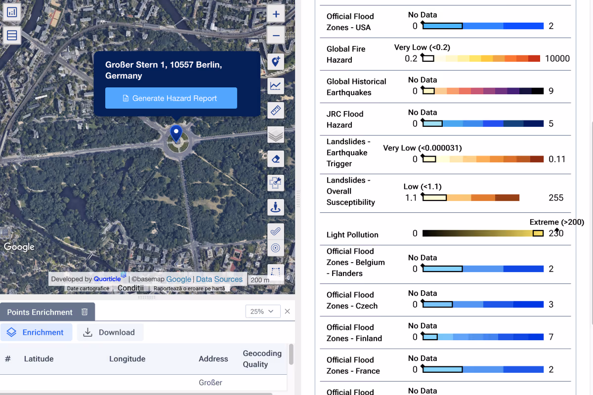
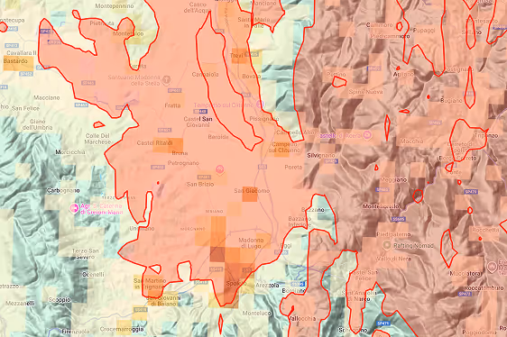
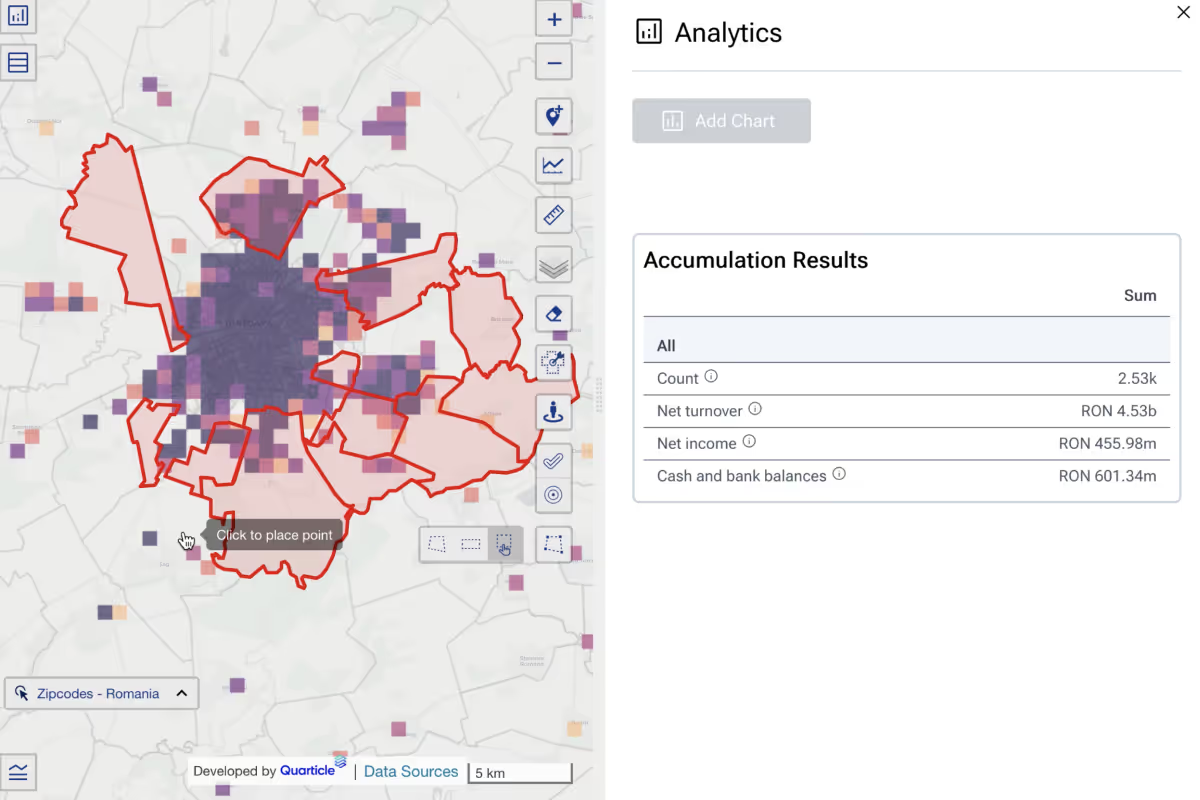
Proactively integrate real-time geospatial analysis and field data to identify high-risk areas, emerging hazards, and exposure concentrations. Automated alerts and predictive analytics help underwriters, claims, and risk teams mitigate potential losses before they occur.

Graph by Quarticle interface showing a circular hazard zone on a map and a detailed "Point Hazard Lookup" dashboard with color-coded risk scales for flood, earthquake, and lightning.

Portfolio Data Enrichment Engine

Transform raw insurance data into structured, enriched datasets for hazard, location, and exposure information, enabling accurate risk modeling, pricing, and compliance with real-time, audit-ready geo-enrichment.

A map view showing a large inland geographic area with various terrain elevations, marked with red irregular boundary lines.

Footprint & Georisk Analysis

Leverage real-time event and hazard data to map exposures across portfolios, regions, and lines of business, enabling rapid underwriting, claims response, and optimized accumulation planning.

A Quarticle Graph interface displaying an event footprint analysis powered by EventHub. The map shows a geographic accumulation analysis with an event footprint overlaying a region. To the right, a detailed "Accumulation Results" data panel summarizes the financial impact, including specific net values and gross values insured.

Underwriting Risk & Accumulation Control

Combine dynamic risk analysis, live portfolio visualization, and automated monitoring to track accumulations, and deliver scalable, compliant insights across millions of policies.

Cloud Container Platform for Insurtech Engines

Run your insurance applications faster, more reliably, and at scale.
Scalability on demand
Easily handle more users, data, or workloads without delays.
Cloud-agnostic & portable
Works on any cloud or hybrid setup, giving you full control.
Enterprise security & compliance
Built-in access control, monitoring, audit trails, and isolation for data protection.

Measurable Impact for P&C Organizations

40%
faster time-to-quote
99.9%
SLA with full auditability and OGC compliance
Scales from 10 analysts to 10M users
3x
less manual intervention across risk workflows
Supports over
15,000+
Property & Casualty underwriters globally
65%
lower infrastructure and licensing costs

Client Success Stories

What our customers are saying

Quarticle’s geospatial intelligence platform allowed us to harmonize our application landscape. We can now manage all geospatial workflows centrally, driving efficiency and effectiveness across our underwriting operations. Providing our customers and brokers with significantly faster, higher-quality services not only reduces operating costs, improves underwriting decisions, and increases margins — it also enables us to deliver a best-in-class experience to our users.
Kai Ole Rogge, Former Head of GIS, Global P&C Insurer with 150,000+ Employees
Blazing fast, cost-efficient, and easy to integrate, RAPID empowers our renewal processes and risk modelling. Fully automated geoprocessing and geo-enrichment of both small books and large portfolios is no longer a challenge. We’ve reduced human intervention by more than 300% — from core insurance systems to scenario modelling, everything is connected and enabled within a short implementation phase.
Kai Ole Rogge, Former Head of GIS, Global P&C Insurer with 150,000+ Employees
Quarticle’s Graph platform is intuitive, reliable, and easy to use. Our teams work more efficiently and confidently, enabling stronger underwriting decisions.
Chief Claims Officer for a large Italy-based Insurer
Transform Your Insurance GeoIntelligence Today
Unify risk data. Accelerate underwriting. Strengthen portfolio control.