

Geospatial and Cloud
Consulting Services

Transform data and platforms into production-ready systems.

Talk to an expert

About Quarticle

Quarticle helps organisations design, build, and run scalable geospatial solutions. We combine GIS expertise, software engineering, cloud architecture, and data analytics to support projects from discovery to deployment and ongoing operations.
Certtified ISO 27001:2002 Information SecurityCertified ISO 9001:2015 Quality Management

How We Work

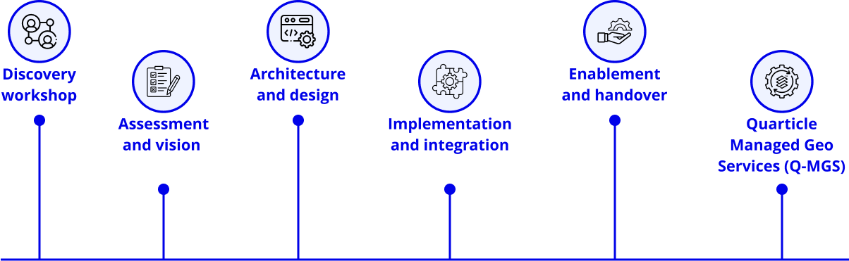
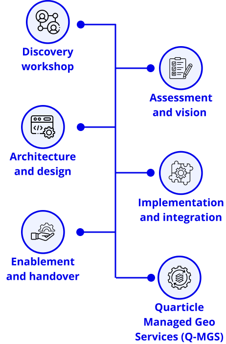
Our consulting services combine strategy, engineering, and implementation to help you move from idea to operational system. Engagements begin with a focused discovery workshop and continue through design, implementation, enablement, and ongoing managed services (Q-MGS).
A scheme showing Quarticle’s consulting process which includes the following steps: Discovery workshop; Assessment and vision; Architecture and design; Implementation and integration; Enablement and handover; Quarticle Managed Geo Services (Q-MGS)

Digital Sovereignty

We design geospatial solutions with portability and governance in mind, helping you avoid vendor lock-in and maintain flexibility across your technology stack. Through our partnership with STACKIT, we enable secure, scalable, and fully GDPR-compliant deployments on European cloud infrastructure.

End-to-End Geospatial and
Cloud Capabilities

End-to-End Geospatial and Cloud Capabilities

GIS Software Development

We build modern geospatial applications with scalable architecture and clean integrations.

Develop custom web and application solutions for spatial workflows

Design APIs and connect them to existing systems and data platforms

Support database migration and modernisation

Set up DevOps and infrastructure automation for stable delivery

Data Strategy & System Integration

We help teams shape geospatial data strategies and connect systems so data flows more efficiently across tools, platforms, and workflows.

Define target data landscapes across source systems and operational environments

Improve data sourcing, quality, and enrichment, including remote sensing and OBIA-based inputs

Design real-time and batch data flows into dashboards, analytical tools, and operational systems

Support interoperability across cloud, on-prem, and hybrid environments

Comprehensive Managed Geo-Services (Q‑MGS)

Q‑MGS provides ongoing access to geospatial technology, skills, and support after implementation.

Operate and optimise platforms, infrastructure, and cloud environments

Monitor systems, manage incidents, and control costs

Maintain applications, pipelines, and geodata catalogues

Support cloud migration, database integration, and continuous improvement

Object-Based Image Analysis

We automate feature extraction and classification from imagery to make large-scale processing faster and more consistent.

Rapid digitisation of features from satellite or aerial imagery

Classification workflows for land use, assets, and environments

Integration into data pipelines and analytical systems

Greater efficiency in processing and interpreting imagery data
Geospatial Data & Analytics

We help teams turn spatial data into insights that support their operations.

Design data pipelines for batch and real-time workflows

Perform spatial analysis and modelling

Integrate dashboards with BI and analytics tools

Structure data for reporting and operational use

AI, Analytics & Embedded Workflows

We connect geospatial intelligence to the tools teams already use, so insights fit into daily workflows.

Integrate with analytics platforms and dashboards

Embed spatial insights into applications and operational workflows

Provide API-driven access for AI and automation systems

Support event-driven data processing pipelines

Geospatial Infrastructure & Cloud Consulting

We design Kubernetes-based, cloud-native geospatial infrastructure for demanding operational and analytical workloads.

Architect geospatial services, containerised applications, and ETL or Airflow pipelines

Deploy across AWS, Azure, Stackit, Google Cloud, private cloud, sovereign cloud, or hybrid setups

Build spatial data infrastructure with PostGIS, managed databases, catalogues, and metadata services

Establish CI/CD, observability, and security models aligned with enterprise requirements

Our Core Competencies

Quarticle combines cross-domain expertise in software development, geospatial systems, cloud computing, IoT, and user experience. Our work is grounded in open-source technologies, geoinformatics, remote sensing, and product engineering.
Software development
Cloud computing and DevOps
Data engineering and analytics
Remote sensing and image processing
Geoinformation and spatial analysis
UX and product design

Team Expertise & Technologies

Our team brings together GIS experts, software architects, developers, and data specialists with cross-disciplinary experience in geospatial systems, cloud infrastructure, and analytics. We use modern, proven technologies to build solutions that are scalable, reliable, and easy to maintain.

Cloud Architecture

AWSAzureGoogle CloudStack IT

DevOps & Infrastructure

Kubernetesdockeransibleapache airflowterraform

Data & Databases

PostgreSQLPost GisMySQL

GIS & Open Source

QGISGrassOsGeoMapServerGeoServer

Data Formats

Request a quote

Fields marked with * are mandatory.
Thank you! Your submission has been received!
Something went wrong while submitting the form. Please try again.