

Closing the Execution Gap in Geospatial Projects

Most geospatial projects don’t fail because the analysis is wrong, but because nothing operational ever truly depends on them. The business case is usually solid, the use case is well defined, and the expected ROI looks convincing on paper. Yet somewhere between prototype and production, momentum starts to fade. Adoption slows, integrations remain partial, and what once felt like a strategic initiative gradually turns into just another underused analytics layer.
In most cases, this isn’t a tooling issue. It’s an execution challenge rooted in the system's design. What’s often missing is not better planning, but the ability to turn location intelligence into something that runs reliably, scales across teams, and actively supports day-to-day decisions. That gap between intent and real-world impact is what defines the geospatial execution gap.
The execution gap: from insight to infrastructure
Most organizations today understand why geospatial analytics matters. The real challenge lies in making it work consistently in practice, at scale, and across the business. A successful system has to do more than generate insights; it needs to run continuously, integrate with existing workflows, support multiple teams, and contribute to measurable outcomes.
Across industries such as insurance, logistics, utilities, and financial services, a familiar pattern emerges: projects perform well in pilot phases but struggle once they are expected to operate as part of a broader system landscape. This is where things begin to break down, and the underlying reasons tend to be the same:
1. Fragmented spatial data across systems
Many GIS implementation challenges begin with the assumption that data is already usable. In reality, spatial data is often scattered across internal systems, third-party providers, legacy platforms, and manual processes. This fragmentation leads to inconsistencies, duplicated effort, and a lack of trust in outputs. Teams spend more time preparing data than using it.
The core issue is not just data quality, but the absence of a unified approach to managing and integrating spatial data. Organizations that succeed here invest in structured data pipelines and consistent data models, ensuring that spatial data is continuously updated, aligned, and ready to support decision-making.
2. Architectures are designed for pilots, not enterprise scale
Many geospatial systems are initially built to answer a specific question. They work well in controlled environments but are not designed to handle the demands of production. As usage grows, limitations become clear: performance drops, integration becomes difficult, and systems require rework. This creates a common scenario where a successful pilot cannot evolve into a reliable enterprise solution.
Modern location intelligence platforms need to be designed with scale in mind from the beginning. Cloud-native architectures, distributed processing, and API-first design are no longer optional; they are essential for supporting real-world usage. Without this foundation, scalability becomes a constant challenge, and ROI is harder to achieve.

3. Insights never reach operations
While dashboards can be valuable, they rarely create impact on their own. When insights remain disconnected from operational systems, they depend on manual interpretation and follow-up, which quickly limits their effectiveness. This is often where projects begin to lose momentum: the analysis may be accurate, but it never becomes part of how the organization actually operates.
Real value emerges when geospatial intelligence is embedded directly into business processes (whether in underwriting, routing, risk assessment, or asset management) so that insights can inform and trigger decisions as part of everyday workflows. That’s the point at which location intelligence starts to deliver measurable ROI.
4. No real-time or event-driven capability
Traditional GIS approaches tend to rely on static analysis, focusing on what has already happened rather than what is happening in the moment. However, many modern use cases require systems that can respond as events unfold. Whether it’s tracking assets, monitoring risk, or adjusting operations dynamically, real-time capability is quickly becoming a requirement rather than a competitive advantage. Without it, organizations are left reacting too late and missing opportunities to automate or optimize decisions.
Moving toward real-time geospatial analytics involves adopting streaming data pipelines and event-driven architectures that enable systems to process and act on data continuously, as conditions change.
5. Lack of ownership and long-term governance
Even well-designed systems can lose value over time without clear ownership and governance. After deployment, many geospatial initiatives lack defined responsibility for maintenance, updates, and alignment with evolving business needs. As a result, data quality can decline, processes become inconsistent, and the system gradually loses relevance.
To prevent this, organizations need a clear spatial data strategy supported by governance frameworks that enable continuous evolution. This helps ensure that geospatial capabilities remain aligned with business priorities and continue to deliver value as requirements change.
The missing link: connecting data to action
A useful way to understand the execution gap is to look at how geospatial systems are structured. In high-performing environments, there is a continuous flow: data sources feed into ingestion pipelines, which are processed by spatial engines, then exposed through APIs or event layers, and finally integrated into operational systems where decisions are made.
Many organizations manage to build the first part of this chain, but struggle to carry it through to completion. The real challenge lies in ensuring that insights don’t stop at analysis, but actually trigger actions within day-to-day workflows. That’s ultimately where the difference between analysis and real business impact becomes clear.
From projects to geospatial infrastructure
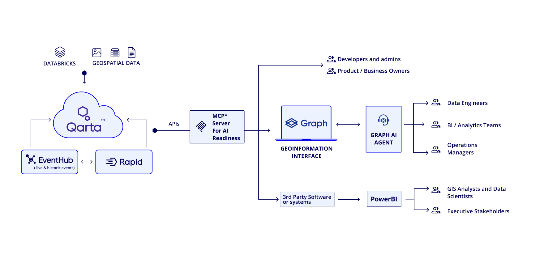
Closing the execution gap requires a shift in mindset. Geospatial capabilities should not be treated as isolated projects or tools, but as part of the organization’s core infrastructure. This means designing systems that scale, integrating them into operations, enabling real-time processing, and aligning technical decisions with business outcomes. It is also where platforms like Quarticle play a significant role by helping organizations move from fragmented implementations to cohesive, production-ready location intelligence systems.
Turning location intelligence into ROI
When implemented effectively, location intelligence can improve efficiency, reduce risk, and speed up how organizations operate and respond. If those outcomes are not being achieved, the issue is rarely the idea behind the project. More often, it lies in how the system is designed and how well it supports real operations.
At Quarticle, we focus on building automated, scalable, cloud-native geospatial systems that connect data, analysis, and action, so that location intelligence becomes part of everyday decisions. If you are looking to move beyond pilots and build systems that deliver consistent business value, reach out, and let’s build a tailored solution for your business.
